
XCAS – Customs Administration System
Modernising border management and trade facilitation for developing country governments.
The Customs Administration System (XCAS) modernises border management and trade facilitation. It enables electronic declaration processing, automated tariff classification, and risk-based selectivity to improve compliance while reducing clearance times.
XCAS integrates with national single-window systems and supports EITI-aligned reporting on extractive industry trade flows.
License Management
Application & Lifecycle
- Full workflow from application registration to license issuance
- Spatial validation, multi-level approval, payment compliance
- First-come-first-served or block tender configuration
- Renewals, transfers, relinquishment, suspension and cancellation
License Profile
- General info: license code, type, owner details, status, dates
- Fee schedule, payment history and receipts
- Digital map with coordinates, area calculation and ESRI export
- All documents, submitted reports, user notes and complete history log
GIS & Spatial Validation
- GeoServer-powered overlap detection and coordinate validation
- Automatic suggestion of revised coordinates for overlapping areas
- Integration of additional geo-data layers (protected areas, topographic, geological)
- WFS, WMS and WCS open standards; ESRI shapefile export
Compliance & Monitoring
Fees & Payments
- Automated fee schedules configured per license type and formula
- Invoice generation with unique reference IDs
- Third-party payment system integration via payments API
- Late payment alerts and automated reminder letters
Reports Tracking
- Monitors quarterly, annual and monthly report obligations per license
- Alerts when reports are due or overdue
- Review and approve submitted reports; flag issues for follow-up
- Reports can be approved, rejected or marked "approved with issues"
My Tasks & Issue Tracker
- Role-based task alerts: pending applications, expiring licenses, overdue payments
- Collaborative issue tracker with comment threads and open/closed status
- Approval process integration for multi-level review workflows
- Email notifications for new tasks and assigned issues
Analytics & Reporting
Dashboards
- Analytics on applications processed, licenses issued and payments received
- Elasticsearch-powered dynamic visualizations and graphs
- Kibana integration for advanced reporting and data analysis
Reports Module
- 36 configurable reports with filters on period, license type, owner and minerals
- Export in Excel or PDF format
- All tabular data available for reporting
Correspondence
- Word-template-based letter generation using template codes
- Payment reminders, notification letters and license certificates
- Invoices with embedded WMS maps from GeoServer
Integration & Administration
Administration
- Configure license types, rules, fees and renewal limits without external support
- Adapt to new or modified mining codes via administrator settings
- User and permissions management via super administrator module
API & Integration
- APIs for submission, payment, document management and issue tracking
- Kibana integration for external analytics
- GeoServer WFS connection accessible from any GIS software on the network
- Training and full API documentation provided
Online Portal (Optional)
- Public transparency portal with live license registry, maps and payment data
- Licensee self-service: submit applications and manage licenses online
- Applications from the portal received and processed directly in MCAS
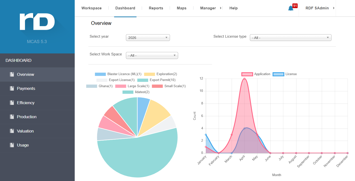
MCAS Dashboard — Overview
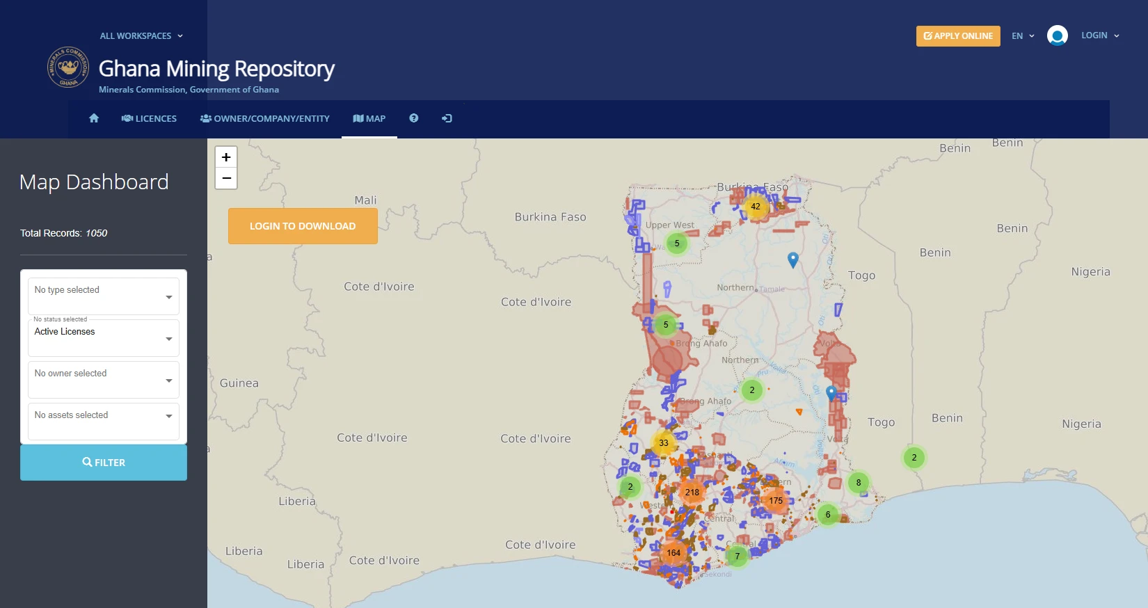
Ghana Mining Repository — Map View